Loch Morar
May 12th
And then we left. The car was parked at Morar railway station and we headed east along Loch Morar. Tarmac changed to bridle way and then to a narrow footpath, twirling beautifully along the loch.

Leaving civilisation
It was easy to predict the next 15 minute weather forecast with the wind coming across the Loch. Grey veils approached and it was a raincoat on-off game. Nevertheless, our lunch was bathed in sunshine and we had time to make tea and coffee.

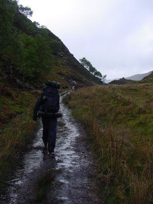
Easy tracking along the footpath along Loch Morar
As the footpath is good and level along the loch it was easy going. Which was just as well as our rucksacks were full of 3 days of food for Brice.

The rain just passed. View east along Loch Morar.
Brice appeared to be fit. Tomoki and I convinced ourselves that Brice was only a mile ahead of us due to his much lighter rucksack and lack of photographic aspirations.

Further down Loch Morar
After about 10 kilometers, the footpath started to climb and turn north. It runs through a huge fault, the pass of Tarbet. At this point we exchanged the sweet water of Loch Morar for the salt water of Loch Nevis.

A picture of the photographer. View west along Loch Morar.
Wet path leaving Loch Morar for Tarbet Bay
Tarbet bay harbours a small settlement with a chapel. The ferry, the one that takes you back to Mallaig, gets here only once a week (Friday). As our food lasted only to Wednesday, it was out of the question. We had to go on.
We climbed out of the bay and were treated to new views, which were pretty spectacular with the bit of sun that came out. Snow, on the not so far away mountain tops, was not promising a comfortable night temperature.
The small Kylesmorar Estate marked the end of the footpath. Just when we reached it, a heard of deer passed us, 40 yards away. None of us was armed with anything impressive, so the barbeque for that evening was postphoned.

The Kylesmorar estate marked the end of the footpath
At the end of the estate, energy was running low, but camping on the narrow corner, Sgeir an t-Sruith, was a bit exposed if the wind would increase and we managed to climb (no more footpath) along the shore until we found a flat bit of grass that did not appear to be under a foot of water at high tide (experienced campers think of these things).
With the sun going down, temperature dropped and wind increased. There was not much socialising and we needed to gather energy for the 8 kilometer stretch planned for the next day..

The o so sheltered campsite
In the semi darkness I studied the map to see how hard the going would be the next day, as the last few hundred yards that day did not promise much good. My idea was to folllow the low tide line along the beach. Beach ?
Time to snore.....
The previous day | next day.